We now have evening in Castle Mountain unexpectedly wireless Internet access, we will send another new message. A map follows with the next message.
The Kootenay is the South-eastern area of British Columbia, includes several high mountain ranges in the north-south orientation. Between them extend beautiful, sparsely populated valleys with rivers and a variety of elongated lakes. Brown and black bears, moose, elk and deer have a wide area. Sorry, we do not see it. The West is more humid rain forest, the east drier and the south because of the heat and the possibility of irrigation extremely fruitful. This summer was (and still is) very hot and dry. The bears floating in the valleys, as they are no berries in the woods.
THE GLACIER NP
strengthened fresh from the spa and the massage, we go to Glacier NP. At the pass, the Rogers Pass (1350m), we set the clock back to Pacific Time (Swiss time + 9 hours) and gain one hours weather permitting.
The Glacier National Park is located in the Selkirk Mountains. This mountain range runs parallel to the Rocky Mountains (Jasper, Banff, Yoho and Kootenay NP) in the north-south direction and is in the east, north and west by the Columbia River fringed, 100 km rises south of Radium Hot Springs and first to the north, then flows to the south. Between Revelstoke and Castlegar, the mouth of the Kootenay River in the Columbia, it becomes a 232 km-long reservoir. Then he turns to the U.S. (Washington) and leads to Portland in the Pacific.
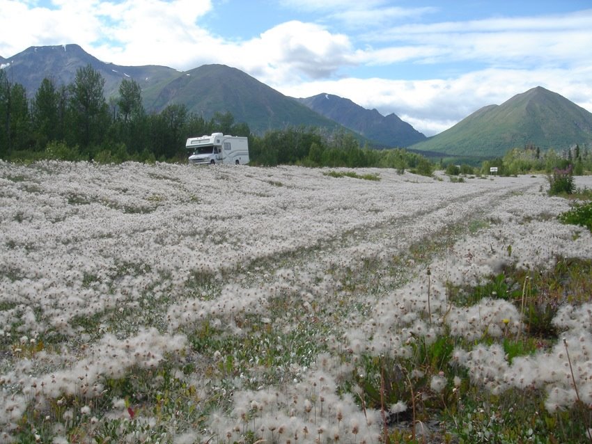
In Glacier National Park there are 440 glaciers. Soon there will be less. We are in the Rain forest. In the 'lonely planet' we read: "it rains here only twice a week - once for three days and then again for four." Peter is sleeping obvious: we have splendid summer weather. At the campground, at 1250 m at a former rail loop of the Canadian Pacific Railway (CPR) is 26 ° in the afternoon!
 The Rogers Pass is a major transition. came as British Columbia 1871 Canadian Confederation, promised the first Canadian President, Sir John A. MacDonald to join within 10 years BC with the existing Canadian rail network. This was a difficult undertaking, as it was to find a way through the Rocky Mountains and the Selkirk to find Mountains. In the Rocky Mountains, the line of Banff, Lake Louise through Yoho NP was performed.
  In the Selkirk Mountains Major AB Rogers in 1881 followed her to the Illecillewaet River from the west and the following year from the east and found the access to the named after him after the pass to him for his service issued check for $ 5,000, he never broke . On 7 November 1885 was inaugurated the railway line. By the way, Swiss railway engineers to build the tunnel turns à la NP were contrived Gotthard Railway in Yoho NP. A delicate range of Rogers Pass was myself. Although situated only 1350 m, covered here in the winter usually 12 feet of snow. Therefore, in the first winter 1885/86 went no trains were first used on the pass than 1904 snow blowers, operating in the winter was possible. But only for a few years, the CPR took over the Rogers Pass
 The disused railway line is now accessible on a 3.8 km wide path. Information boards tell of the earlier work. To supplement the finances of the railway was here, what is today the camp grounds - as before in Banff and Lake Louise
 - built a hotel. Tourism began to flourish. Swiss guides were hired, which opened up many mountain tops for the tourists. The area reminds us of Morteratsch: The curve of the railway line, the forest, glaciers and mountain peaks in the background. Then came
 the horror: On 4 March 1910 were workers engaged in the digging to free an avalanche buried next to a tunnel route, as an unexpectedly thundered down from the opposite side and an avalanche buried 60 workers. A 4 km long tunnel was built. This meant the imminent end of the hotel operation. In 1925 the hotel was closed and dismantled. In the 80 years, another 14 km-long tunnel built (the longest on the North American continent), but the ride is due to ventilation problems, hardly.
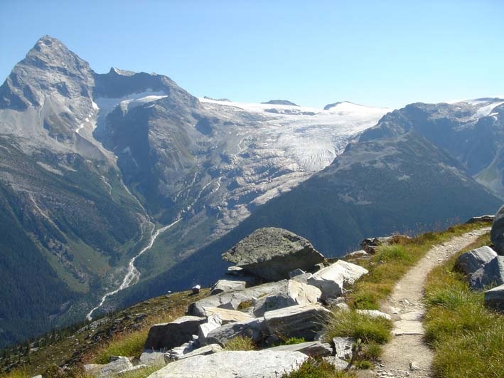
attracts us to the mountain on Sunday. At half past eight clock we go in the shady forest to beautiful hiking trails in the air. Presumably, this way of the former Swiss Guides created. He skillfully overcomes some steep rocky barriers. At the Abbott Ridge (a ridge) are expected after 2 ½ hours of climbing an unprecedented view of mountains and valleys. 345 ° will be the panorama of glaciated peaks. We can not get enough. And what is good: no cow pies, no sheep's dung, no noisy tourists. Only on the way down we meet a dozen people, mostly Europeans.
IN EASTERN Kootenay
In the town of Revelstoke, we camped right on Williams Lake, a nearly 25 ° warm lake, what comes to us very well. The next day we drive on virtually traffic-free road to the Upper Arrow Lake dammed Columbia River along the south and cross it in a twenty-minute ride on a free ferry. Everywhere in the woods we see smoke and see and hear helicopters, already bringing the fire water. People have become accustomed to the many forest fires that are attributable in large part of human negligence.
to Halycon Hot Springs invites us to turn a spa to relax. The campground is similar but more like a gravel pit, says Esther, but the bathroom is excellent. About 50 m above the steep forested lakeside created, there are four pools with temperatures of 12 to 42 °. In the evening we enjoy a massage again. This time comes at Urs his account: a painless, gentle treatment by female hands. The Masseuse tells us much to go to Osoyoos. There the climate was warm and dry, not humid like here. Tätsächlich and it starts to rain and the same, and we reflect on their advice
About Nakusp is it the next morning southeast of the Kootenay Lake, the dammed river, we drove along in the national park. Since there are almost continuous rains, we do not go on walks and Nelson to Castlegar. This shows again the sun. It had been raining here just ten minutes, and yesterday it was 35 degrees was warm. The rain was badly needed for vegetation. Tomorrow we head to the West Kootenay.