
THE RICHARDSON HIGHWAY (Valdez - Delta Junction) had
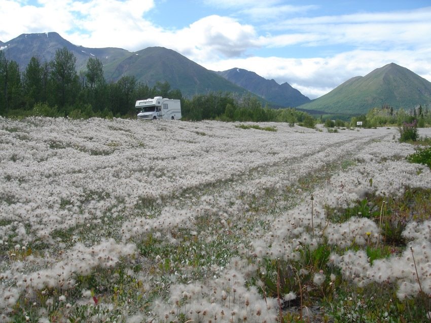
The earthquake of 2004 damaged the Glenn Highway between Glennallen and Tok strong. From a trip to this 220 km, we were strongly discouraged. Consequently, we make the 100 km detour to Delta Junction. The drive through the Chugach Mountains, is at the western edge of the mountain peaks of the Wrangell-St.Elias NP and along the eastern Alaska Range varied. We enjoy the view of the snowy mountains, huge glaciers, vast valleys. The Wrangell-St.Elias NP NP is the largest in North America and larger than Switzerland. With the Mount Logan, located in Canada, however, he even almost a six-thousand (19'550 ft./5950 m). Incorrectly it is spent on some maps, and so in the new Center Wrangell-St.Elias than six thousand (19'850 ft./6050m). At last the weather is sunny. The road ride is very weak, and we relax a little unusual from the hustle and bustle of traffic from road to Kenai Iceland.
The construction of the Richardson Highway is back as the other roads on the Alaska Gold Rush. First, a trail of Valdez (the Delta Trail) applied across a glacier. At the beginning of the 20th Century was extended then a road through the Thomson Pass, in the 2nd World War II was extended for strategic reasons.
opened in 1973, 800 miles long Alyeska pipeline runs parallel to the road. A dozen pumping stations to ensure that the warm above 40 ° C within a week, crude oil is pumped from Prudhoe Bay to Valdez over three mountain ranges. At one of the major geological fault places in America, the Denali case, in the event of an earthquake made provisions: the tubes can move horizontally vertically to 7 m, up to 2 meters. Many information boards give us information about the numerous problems of the pipeline, the play is beyond the scope of the blogs. The current reduction of BP because of corrosion damage to a quarter of the normal amount of gasoline has driven the price up.

In Delta Junction, the official end of the Alaska Highway, the flows from the south of the Alaska Range next Delta River in the Tanana River, which flows from the southeast along the border with Canada since the Alaska Highway. From the river bank we have a magnificent view of the white peaks of the Alaska Range: Mount Deborah (3639m), Hess Mountain (3761m) and Mount Hayes (4216m). Nearby stands the Donnelly Dome (formerly Delta Dome), the weather symbol for Delta Junction: Two weeks after the only 3910 ft high and therefore only about 500 m above the DJ uplifting summit is covered with snow, DJ falls in the first snow. THE ALASKA HIGHWAY
(Delta Junction - Haines Junction)
from Delta Junction we drive southeast along the Alaska Highway, First Tetlin Junction to a distance that we at 11.7. had traveled. The ride through the beautiful woods is peaceful. Again, we can enjoy the ride on the low traffic street. The mountains of Wrangel NP in the southwest form during the whole trip a beautiful setting, which always stimulates their transit stops. Then it goes in the same direction, and soon We cross the border to Canada (Yukon). Belonging to the Alaska route to this point is 'only' 322 km. The rest, 1969 km, runs through Canadian territory (Yukon and British Columbia).
The border between Alaska and the Yukon was established in 1908 definitely. A 6m wide swath stretching from south to north along the 141st Longitude by tundra and taiga. Haines Junction is to show the landscape monotonous. So I do not miss anything if I have to concentrate fully on the road. The road surface is bumpy and that is riddled with pot holes, and several times we go through miles of construction sites. The RV is again covered with a solid soil crust. We choose not to clean it, because the onset of rain soon washes it himself, more or less clean.
At Kluane Lake, we stay in a fantastic location right on the lake shore. We want to once again enjoy the sun. We sit at the window overlooking the lake, which is stirred by the strong Bise. White crests race across the water. All the next day it rains!
On the spacious grounds of the Camp Ground, about 500m along the lake attracts pamper themselves often Grizzlies to grow since many berries. We see many of the perennials Canada Buffalo Berry (Soopolallie), which is rich in vitamin C, but also causes diarrhea. We can find the traces at the park entrance: a mash of bright red berries, which has eliminated the bear almost undigested again. Show on the east side, so it warns us, often a bear, on the west side of a mother with two boys. At the end of our transition game, we must admit that we are really happy to have not met them!
THE HAINES Higway (Haines Junction - Haines)
include the 250 km to the Lynn Canal on the Pacific coast to the most beautiful stretches of Alaska, and we take our time. Moreover, from the sun is shining and so we can make a few walks.

The connection to the sea through the mountains inland was a long time by the Tlingit Indians closely guarded secret. Only they drove over the Chilkat Pass trade in the Athabasca Indians of the interior. In the days of the gold rush it was a white man, Jack Dalton, to elicit the Indians this mystery. He put 1894 on a trail to Fort Selkirk on the Yukon just before Dawson City, ie every 20 miles he installed Camps (tent accommodations with meals), and collected massive street duties. The Tlingit, he was behind trying to turn it off by the tents away with the inventories. But Dalton was able to eke by, he lay back in the cold winter without provisions 80 km on snow shoes.
began in 1943 the United States to build the road today as a feeder to the Alaska Hwy. 20 years is not required for the simple route. She was always extremely problematic as topographical road. In 1970, the passage was controlled at five posts. Came a car within a specified time from one heading to another, was immediately sent a rescue team. Just before we Haines
cross the border to Alaska - and it starts raining again. The thermometer does not rise above 11 ° C.
HAINES
One evening we drive along the bay to the Chilkoot Lake. For two hours we are waiting on the river, which flows from the lake to watch the Grizzly, which each evening on the bank shows. But today he does not show up. It has quite a lot of people that are heranchauffiert buses. A large proportion of them are probably passengers of the cruise ship anchored in Haines. Suddenly we see a wolf for a few seconds. Fifteen minutes later he appears again. Word gets around, and prompt us stand around 20 people. Because this talk, there was no longer the wolf! But once the people are gone, we can some time even two wolves that look over us, watching and filming.
Skagway Skagway is the most important testimony of the Klondike Gold Rush.
 here to put the steamer from Seattle, and the 30,000 Stampeders set about to reach the Pacific coast, the 800 nautical miles from Dawson City. In winter 1898/99, everyone is trying all his by the Canadian authorities demanded and controlled material (around one tonne) the steep path on the glacier (Chilkoot Pass) to create the Lake Bennett over what he the pass 20-40 times cross had (see blog from 11.7.). The cemetery where buried, especially people under 45 years are testimony to the climate problem and hygienic living conditions. Within a year
  the entire forest in the area of Skagway and the Bennet Lake was cleared. At the Bennet Lake Stampeders built for their onward journey by water vessels.
 four cruise ships in port have created, therefore romp over 1,000 tourists in town. The White Pass Railway is apparently all available locomotives and cars.
We also make the ride, but only in the evening. We are lucky: it does not rain and we enjoy the ride with views of the Lynn Canal and the mountains. It is brighter. In fact, they are still there, the sun!
On a bridge to brake the train. Two bears also use them to cross the gorge. Somehow they feel that our train is stronger with three locomotives and 13 cars as they, and are reflected immediately on the other side in the bushes.

Skagway - Prince Rupert (northern part of the Inside Passage)
our original travel plan, we had already changed in late May (before the start of the rainy summer!): Instead of Skagway to go back to Whitehorse, then to the Cassiar Highway to the Yellowhead Hwy reach, we booked via the Internet, the Inside Passage to Juneau (three nights) to Prince Rupert (Canada). We save 1000 miles by car and hope to pass on a fantastic journey through fjords, of glaciers and mountain peaks, on whale watching, to hiking, etc.
JUNEAU
arrival by 20 clock with the Alaska fast ferry Fairweather (ironic name!). She drove significant 38 Knots (nearly 70 km / hr.)!
Upon arrival it is pouring rain. We ask: Does it always rain here? And one answer: No, sometimes it snows! That autumn has begun, is for us a little comfort. In a brochure we read that there are in Juneau per year 250 inches of rain and 250 cm of snow. Skagway is 60/100 cm drier than Zurich. As a small consolation to the coast at Little Port Walter 550 cm rain and snow CM 300. For us a reason not to go there. At the same time we see on the Internet that it rains in Switzerland and cold. In southern Canada, the Okanagan Valley, on the other hand, it is 31 degrees warm. In two and a half weeks we are there and hope that we then another enjoy the rest of this heat.
Juneau is the capital of Alaska. It is made of about 30,000 inhabitants, lies on a narrow coastal strip, where a 30-mile road running alongside it. The hinterland, there is no road link. So it is reachable only by plane or ship. The airport is 15 km from the downtown. He has two slopes: a 2 km long for conventional aircraft, and parallel to a lake for seaplanes. The ferry terminal is located further 5 km. However, there are a large passenger port in the Downtown. On Sunday, four large cruise ships anchor. Accordingly, the densely populated town of kaufwütigen tourists from all over the world. Actually
Juneau has a lot to offer, and we had the intention of some nice hikes to glaciers and mountains in view to make. The hinterland is a vast ice field, stand out from the mountain top like islands. Instead, we get to the glacier (it is located at 30 m height on the outskirts of the city), in the Mendel Glacier Hall (20 km long and 2.5 km wide) that comes down from the Arctic Ocean pushes. An impressive sight, even if through a veil of rain. We observed swarms of salmon spawning, strenuous work for females as for males. The latter must constantly defend themselves against competitors by biting them even in the tail. In addition to the stream bed a bear the remains of his meals are left. Of the salmon he eats only the brain and the eggs, a ranger tells us. The rest was almost inedible because the salmon eaten since leaving the ocean any more and their meat is tough.
We enjoy our last day in Alaska with a delicious salmon dinner, which we eat everything, because the salmon was of course the young catcher.
Tomorrow morning at 6.15 we are waiting at the port on our boat, which takes us in 28-hour drive to Prince Rupert, where it currently also raining!

0 comments:
Post a Comment